On the evening of 6 June 1944, D Company of the Queen’s Own Rifles of Canada took the Norman village of Anisy "after a sharp brush with the enemy". It became the battalion’s most forward position that night, after a landing that same morning on the beach at Bernières-sur-Mer, according to the account published by the Queen’s Own Rifles of Canada Regimental Museum. The riflemen had fought their way almost seven miles inland.
Today, the same road takes about fifteen minutes by car. In Anisy itself, the regimental memorial and Rue Clarke Lawson are both on the 2.5 km village walk published by the Cœur de Nacre tourist office. Below is the day hour by hour, the places to see between the beach and the village, and a practical guide for following the regiment without a tour.
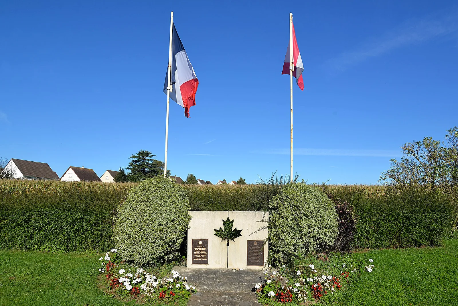
What did the Queen’s Own Rifles do in Anisy on D-Day?
The regiment belonged to the 3rd Canadian Infantry Division, which landed on Juno Beach. Of the four battalions in the first Canadian assault wave, three were rifle regiments: the Queen’s Own Rifles, the Royal Winnipeg Rifles and the Regina Rifles.
- 8:12 am: A and B Companies touched down at Bernières, either side of the railway station (Queen’s Own Rifles Museum).
- 8:30 am: C and D Companies landed in turn.
- 9:00 am: Bernières was cleared, and C and D Companies pushed inland along the brigade’s axis.
- Afternoon: the column moved through Bény-sur-Mer, Basly and Colomby-sur-Thaon, supported by the tanks.
- 5:30 pm: the battalion reached Anguerny Heights, its D-Day objective. C Company held Anguerny and D Company held Anisy, as Rifleman Wagar recalled.
- The cost: 61 other ranks killed or died of wounds, 6 officers and 69 other ranks wounded. These were the heaviest casualties of any Canadian unit that day.
From Bernières to Anisy: the places of 6 June
The regiment’s day falls into three places, from north to south: the beach in the morning, the open farmland in the afternoon, the village in the evening. This route picks up where the journal’s guide to the Canadian sector in one day leaves off.
Bernières-sur-Mer: the morning on the beach
Reveille came at 3:15 am on board the SS Monoway. The sea was so rough that the amphibious tanks could not swim ashore with the infantry, so the regiment had to take Bernières without them. The order to go in came at 8:05 am, says the regimental museum.
B Company landed directly in front of a concrete strongpoint that was still firing. Almost half the company was lost in the first dash across the sand. That bunker now carries a large aluminium regimental badge and a bronze plaque (Queen’s Own Rifles Museum).
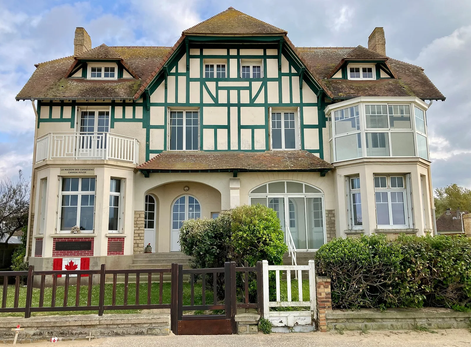
A few steps away on the seawall stands the half-timbered villa seen in so many D-Day photographs. Built in 1928, Canada House is where riflemen used grenades to flush German soldiers out of the cellars. It even appeared on a Canadian stamp issued on 7 November 1994 (Cœur de Nacre).
From Bény-sur-Mer to Anguerny: the afternoon inland
Once clear of Bernières, the battalion followed the road south. It ran through Bény-sur-Mer, Basly and Colomby-sur-Thaon before climbing to Anguerny Heights, ground the regimental history calls of great tactical importance to the division.
Anguerny now has a stone memorial and an inukshuk, unveiled on 5 June 1994 (Queen’s Own Rifles Museum). On the wall around a large crucifix, already standing on 6 June 1944, a copper plaque recalls that Rifleman Bill Ross and his comrades spent their first night in Normandy here. It was dedicated in June 2009, with Bill Ross and his family present, and was given by the WBS Association and the CM2 pupils, the final year of primary school, in Anisy (Queen’s Own Rifles Museum).
Anisy: the evening of 6 June
D Company took Anisy late in the day. The village marked the regiment’s deepest point, about twelve kilometres from the beach according to the Cœur de Nacre tourist office.
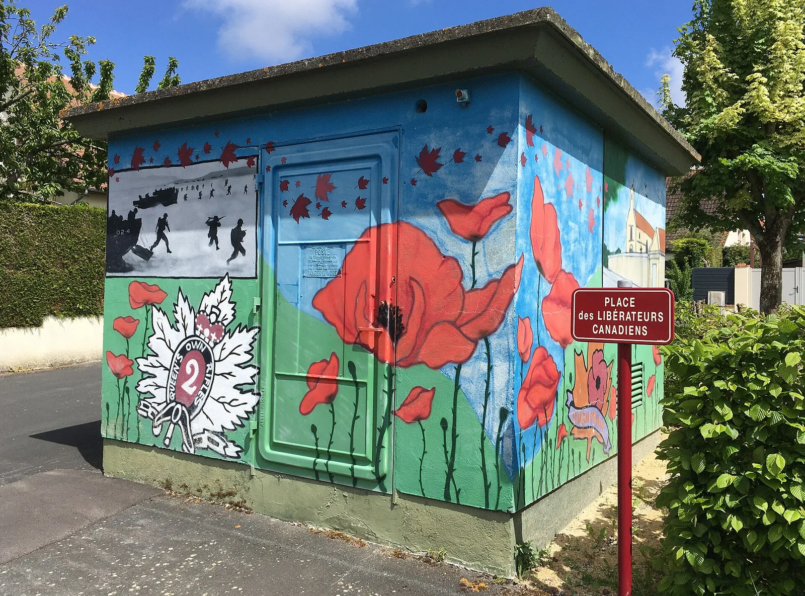
Several traces of that evening can still be seen from the street. An electricity substation is painted in the colours of the Queen’s Own Rifles, and a square is named Place des Libérateurs Canadiens, after the Canadian liberators. Rue Principale came through the bombing of June 1944 completely intact. On the front of the former grocery at number 27, the restored mark of a shell impact is still visible (Cœur de Nacre village walk).
What to know before you follow their route
D-Day objective or most forward position?
The regimental history names Anguerny Heights as the objective of the day and Anisy as the most forward position. Rifleman Wagar, for his part, describes Anguerny and Anisy as the two objectives assigned to the regiment. At the 50th anniversary in 1994, Lieutenant Colonel Barnett Danson called Anisy "the only one reached and held of all allied D-Day objectives" (Queen’s Own Rifles Museum). That is the regiment’s own reading, and it is worth presenting as such. The same museum also notes that the 3rd Canadian Division made the deepest penetration of any Allied division that day.
Clarke Lawson, a name on a street sign
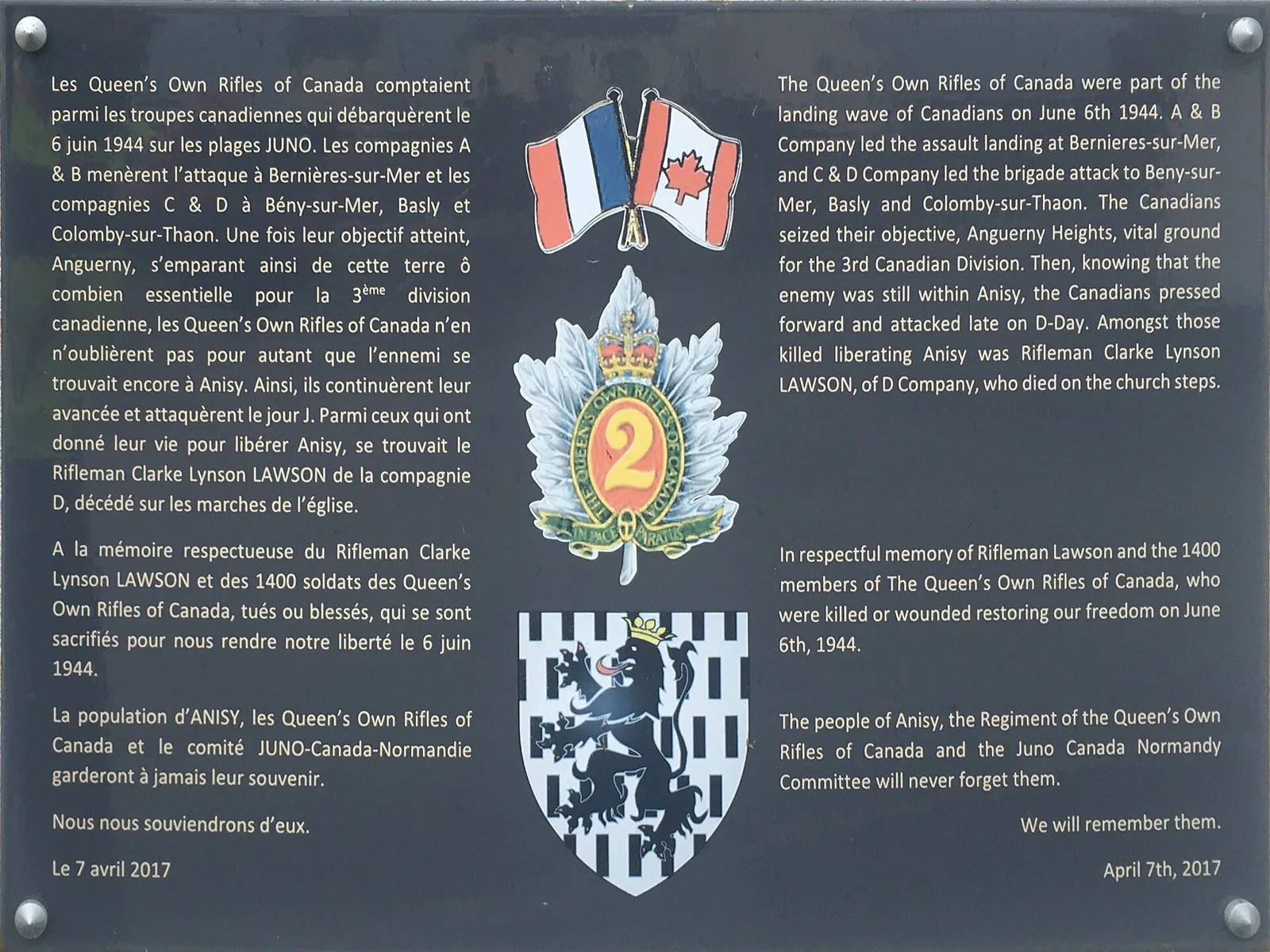
Rifleman Clarke Lynson Lawson was born on 8 May 1905 in Brighton, Ontario, and worked as a farmer. He survived the landing and was killed later that day while liberating Anisy (Queen’s Own Rifles Museum). He was 39. He lies in Bény-sur-Mer Canadian War Cemetery, grave reference "I. F. 4." (Veterans Affairs Canada).
In 2017, with members of the regiment present, Anisy named a new street after him. The link grew stronger in 2024, when Brighton council approved twinning with Anisy on 4 March and Anisy council followed on 5 March (Queen’s Own Rifles Museum). For visitors from Ontario, the village is now a sister town.
Good to know. Canada House can only be visited by appointment, and several houses on the Anisy walk are private: they are seen from the street. The pavements in the village are narrow.
Itinerary: following the Queen’s Own Rifles' D-Day road to Anisy
The road of 6 June covers about fifteen kilometres, roughly nine miles. It can be driven in the 1944 order, from the beach to the village, or in reverse from Anisy.
| Place | What you see | Distance from Anisy | By car |
|---|---|---|---|
| Queen’s Own Rifles memorial, Anisy | Stone with a maple leaf | 1 km | 3 min |
| Rue Clarke Lawson, Anisy | Canadian plaque | 1 km | 3 min |
| Bill Ross plaque, Anguerny | Crucifix and 2009 plaque | 2 km | 5 min |
| Anguerny memorial | Stone and inukshuk from 1994 | 3 km | 5 min |
| Bény-sur-Mer Canadian War Cemetery, Reviers | Graves of the 3rd Division | 9 km | 12 min |
| Canada House, Bernières | 1928 villa on the seawall | 12 km | 15 min |
| Queen’s Own Rifles bunker, Bernières | Regimental badge | 12 km | 15 min |
| Juno Beach Centre, Courseulles | Canadian museum | 13 km | 16 min |
Driving times calculated on 8 October 2026 with the free OSRM route planner, without traffic, from the centre of Anisy.
Day 1: from the beach at Bernières to Anisy
Start the morning at the Juno Beach Centre in Courseulles, the only Canadian museum on the D-Day beaches. Allow at least an hour and a half for the museum, plus 45 minutes for the guided tour of Juno Park, run from April to October (Juno Beach Centre). Then drive to Bernières and walk from the regiment’s bunker to Canada House.
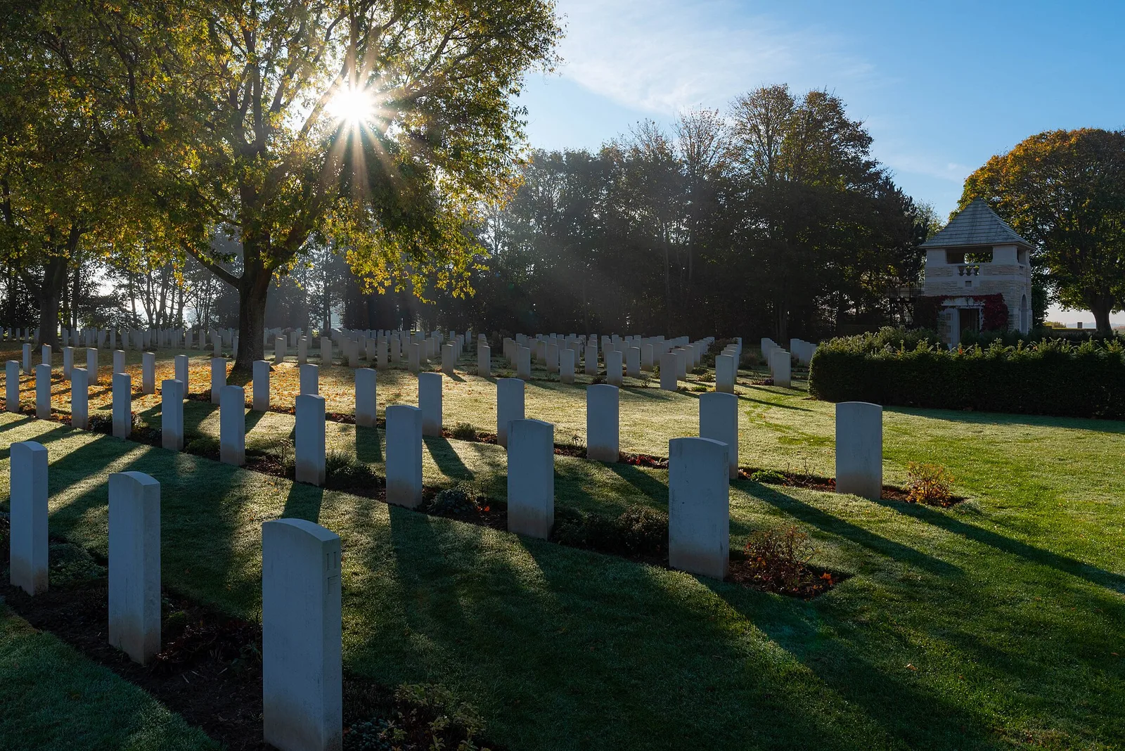
In the afternoon, head south through Bény-sur-Mer. Despite its name, the Canadian war cemetery stands near the village of Reviers. It holds 2,049 headstones enclosed by pines and maples, and the registry buildings at the entrance have platforms that look over the whole site (Veterans Affairs Canada). Carry on through Basly and Anguerny, and reach Anisy around 5:30 pm, the hour the battalion was digging in on the heights. To plan the cemetery visit and find a particular grave, see the journal’s guide to Bény-sur-Mer Canadian War Cemetery.
Day 2: Anisy on foot
The next morning, the Cœur de Nacre walk starts from the town hall car park on Rue de la Chênaie. It covers 2.5 km and takes about an hour. Along the way it passes the substation in the regiment’s colours, Place des Libérateurs Canadiens and the plaque on Rue Clarke Lawson. It also points out the boules ground, where Allied soldiers had a medical post in early July 1944.
Practical guide to the regiment’s places
All of the regiment’s memorials are outdoors, apart from Canada House and the Juno Beach Centre.
The memorial and Rue Clarke Lawson, Anisy
- What you see: a stone memorial with a maple leaf, marking the capture of the village (Queen’s Own Rifles Museum), and the Canadian plaque on Rue Clarke Lawson.
- From Anisy: 3 minutes by car, or on foot.
- Admission: on the public road, no ticket.
- Good to know: the memorial was unveiled in 1994, for the 50th anniversary, in front of the regiment’s veterans.
The Anguerny memorials and the Bill Ross plaque
- What you see: the 1994 stone and inukshuk, and the plaque on the crucifix wall.
- From Anisy: 5 minutes.
- Admission: outdoors, no ticket.
- Good to know: Anguerny also has a street named after the regiment since June 2004 (Queen’s Own Rifles Museum).
Bény-sur-Mer Canadian War Cemetery
- What you see: the graves of the 3rd Canadian Division, including that of Clarke Lawson.
- From Anisy: 12 minutes.
- Admission: the official pages of Veterans Affairs Canada mention no ticket or fee.
- Good to know: according to the French Ministry of the Armed Forces, 335 soldiers killed in the landings lie here (Chemins de mémoire).
Canada House and the bunker, Bernières-sur-Mer
- What you see: the villa at 34 Avenue des Français and the bunker topped with the regimental badge.
- From Anisy: 15 minutes.
- Admission: bunker and seawall open to all; the house by appointment only.
- Good to know: the Juno Beach Centre, 16 minutes away, publishes its opening hours and prices on its official website; it is closed in January and on 25 December.
Why stay north of Caen for this route?
From north of Caen, the beach at Bernières is a quarter of an hour away and the Bény-sur-Mer cemetery twelve minutes. The house stands in the very village where the regiment ended its day, and the memorial is an evening stroll away.
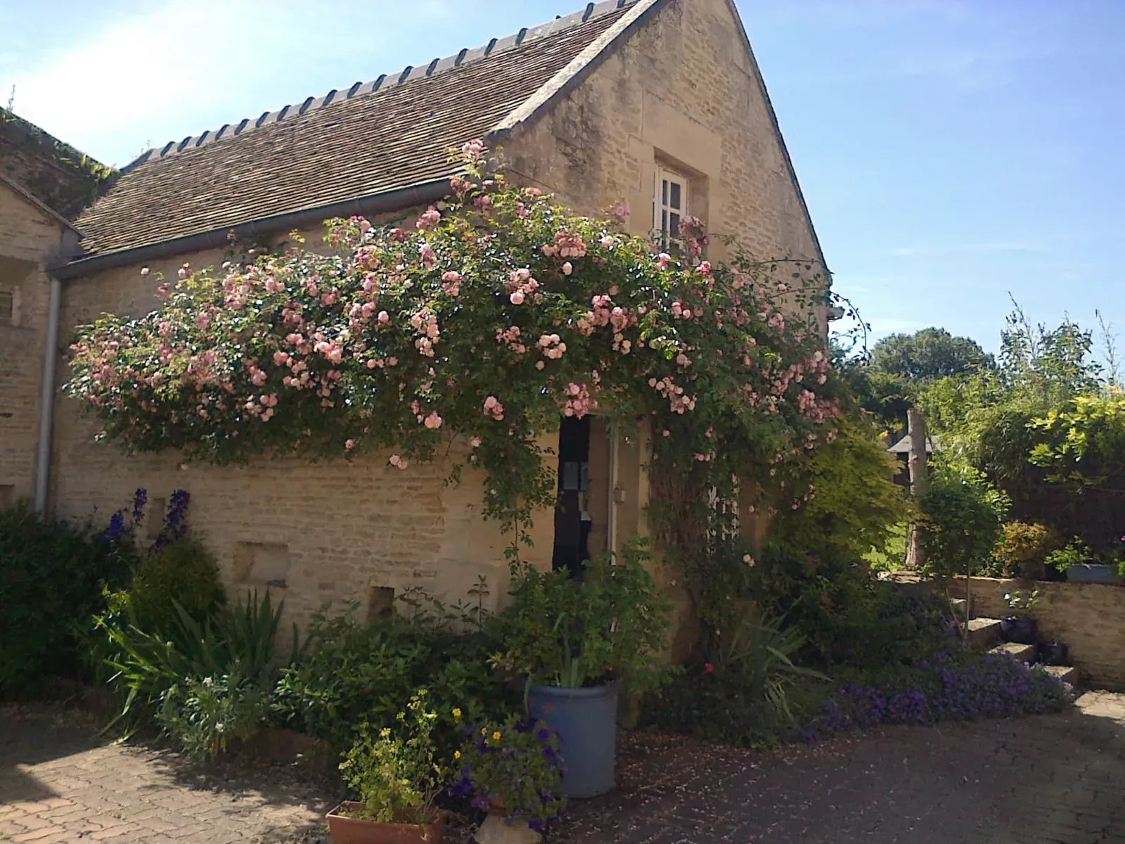
La maison bleue is an 18th-century stone cottage for four guests, in a peaceful village of about 700 people. Restaurant recommendations wait on the fridge, since the village has no shops or restaurants. Two guests put it this way:
"Anisy is such a charming village (we met lots of friendly people on our walks) and yet it’s a short drive to Caen." Jill, May 2022
"The village has an interesting walking tour and it is very quiet." Denise, April 2024
Available dates and the price of each night are in the house calendar. Requests go straight to Patricia, who replies in French, English or Italian.
Tips for a day on their trail
Email Canada House several days ahead, since visits are by appointment only. Keep Anisy for the late afternoon, in the same order as the day in 1944. Bring walking shoes for the village loop and the seawall at Bernières. The beaches themselves are free to walk, as the journal’s article on the D-Day beaches and UNESCO World Heritage explains.
Key takeaway. From the beach at Bernières to the memorial in Anisy, the Queen’s Own Rifles' road is a fifteen-minute drive. One day is enough to follow it, with the Bény-sur-Mer cemetery on the way, and the village itself takes an hour on foot the next morning.
Frequently asked questions
Who were the Queen’s Own Rifles of Canada?
They were a Canadian infantry regiment in the first assault wave on Juno Beach. They landed at Bernières-sur-Mer at 8:12 am on 6 June 1944. By evening, their D Company held Anisy.
How many Canadians landed on D-Day?
Some 14,000 Canadians came ashore on Juno Beach that day, and 359 were killed (Veterans Affairs Canada). The beach covered eight kilometres of coast, from Graye-sur-Mer to Saint-Aubin-sur-Mer. The Queen’s Own Rifles suffered the heaviest losses of any Canadian unit.
Where is Clarke Lawson buried?
He lies in Bény-sur-Mer Canadian War Cemetery, near Reviers. His grave reference is "I. F. 4." The cemetery is twelve minutes from Anisy by car.
How long does the Anisy village walk take?
The tourist office loop is 2.5 km long and takes about an hour. It starts from the town hall car park. It passes Rue Clarke Lawson and Place des Libérateurs Canadiens.
What links Anisy and Canada today?
Since March 2024, Anisy has been twinned with Brighton, Ontario, Clarke Lawson’s home town. A street has carried his name since 2017. Its Canadian plaque is one of the stops on the village walk.